RiverTools

RiverTools

0/5
ver. 4.0
(downloads: 7)

The application was developed to assist you in working with digital elevation models. You can import data from different GIS solutions or remote sensors.

Download
Update date:
11.11.2023
Developer:
Rivix, LLC
Windows version:
Windows XP

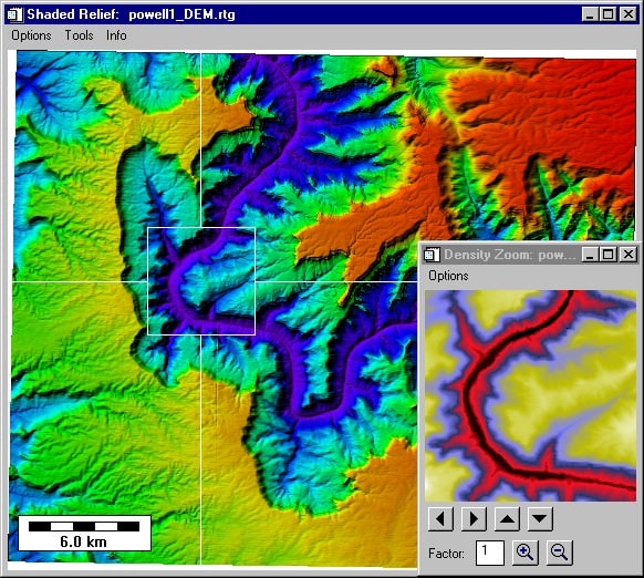
RiverTools is an intuitive GIS program for Windows which provides features for analysis and visualization of digital terrain, watersheds and river networks. One of its main advantages is the capability to extract drainage patterns and process hydrological data from large DEMs.

Main capabilities

Using this software, you can conduct comprehensive analysis of watersheds, sub basins and river networks in a short amount of time. It delivers accurate measurement of characteristics like upstream area, channel lengths, elevation drops, slope and curvature with the help of the Earth ellipsoid model.

It is possible to delineate catchment boundaries and calculate multiple basin and subbasin parameters. There is support for importing and exporting data from other GIS applications. You can also interact with remote sensing, image processing systems.

GUI extension

By default the utility relies on a user-friendly graphical interface for access to its capabilities. This includes powerful mosaicking, visualization and analysis routines. It is worth mentioning that you can also use the tool together with IDL, an easy to use programming language.

Please note that the solution is distributed on a paid basis. However, you have the option to request a demo by sending your contact details to the developers. You may also try a free ArcGIS extension called ArcSWAT.

Features

  • free to download and use;
  • compatible with modern Windows versions;
  • allows you to perform hydrological analyses;
  • you can visualize watersheds and river networks;
  • it is possible to import data from other GIS apps.
Download
(downloads: 7)
Add comment
0/5
Similar programs
GeoSetter GeoSetter
Windows XP, Windows Vista, Windows 7, Windows 8, Windows 8.1, Windows 10 Free
4/5

This app is designed to change the shooting coordinates. Thanks to this utility, it is possible to add GPS information to a photo. There is also a metadata editor.

ver 3.5.3
Infix PDF Editor Infix PDF Editor
Windows XP, Windows Vista, Windows 7, Windows 8, Windows 8.1, Windows 10 Free
0/5

The program allows you to edit PDF files. You can insert text, images, links, and other elements. It also provides the option to set a password.

ver 7.5.2.0
ConceptDraw ConceptDraw
Windows Vista, Windows 7, Windows 8, Windows 8.1, Windows 10 Free
4/5

This utility is a tool for creating professional and technical diagrams, business charts, and graphs. It is possible to use ready-made layouts and templates.

ver 11.0.0.0
Mimio Studio Mimio Studio
Windows 7, Windows 8, Windows 8.1, Windows 10 Free
3/5

This desktop program offers you tools for conducting interactive lessons. Moreover, this application allows teachers to create presentations and display slides.

ver 11.31
Micromine Micromine
Windows 7, Windows 8, Windows 8.1, Windows 10 Free
5/5

This mining and geological information system is used for creating 3D maps and planning projects. The application also supports data visualization features.

ver 11.0.0
gretl gretl
Windows XP, Windows Vista, Windows 7, Windows 8, Windows 8.1, Windows 10 Free
0/5

This program allows for the investigation of economic processes using statistical methods. In addition, the application includes tools for analysis and graphing.

ver 2020e
English Grammar In Use English Grammar In Use
Windows XP, Windows Vista, Windows 7, Windows 8 Free
3/5

This program allows you to study English grammar independently. The utility contains 130 lessons, each with both theoretical parts and practical exercises.

ver 1.2
wxMaxima wxMaxima
Windows XP, Windows Vista, Windows 7, Windows 8, Windows 8.1, Windows 10 Free
4/5

This program allows you to perform mathematical operations, find equation roots, and plot function graphs. The app also supports working with symbolic expressions.

ver 5.44.0